


This article will explore the definition, principles, methods for enhancing orientation accuracy, and applications of satellite orientation technology.
What is Satellite Orientation in GNSS?
The development of Global Navigation Satellite Systems (GNSS) has made satellite orientation technology an important part of modern navigation. This article explains its definition and operating principle, compares it with traditional orientation methods, and outlines ways to improve accuracy and typical applications.
Definition
Satellite orientation technology determines the orientation or attitude of a carrier by receiving and processing signals from satellite systems such as GPS, GLONASS, Galileo and BeiDou. It uses satellite carrier-phase interferometry to determine the direction of a geometric vector formed between two points in space within a specified coordinate system.
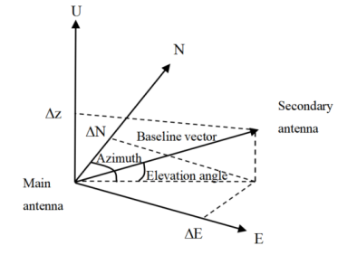
Note: The two points generally refer to the physical phase centers of two measurement antennas. The coordinate system may be Earth-Centered, Earth-Fixed (ECEF) or a local horizontal coordinate system. In a local horizontal system, the baseline vector can be used directly to calculate azimuth relative to true north and elevation relative to the horizontal plane.
Comparison With Traditional Orientation Methods
Different orientation methods have distinct characteristics and application ranges. The following figure compares GNSS dual-antenna orientation with magnetic, geometric, astronomical and gyro-theodolite methods.
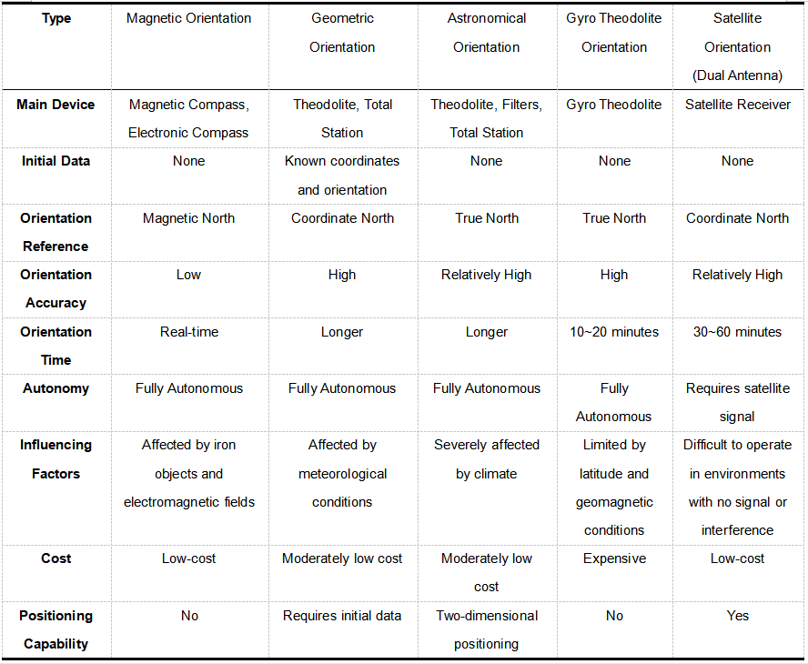
It is evident that compared to traditional orientation methods, GNSS orientation offers the following advantages:
1. High precision: It can deliver high-precision target orientation for a wide range of application scenarios.
2. Real-time output: It provides directional information in real time for monitoring and navigation.
3. Interference resistance: With suitable antenna design and signal processing, it can reduce the impact of interference and multipath, improving measurement accuracy and stability.
4. Low cost: The required equipment is comparatively simple and economical, supporting broader adoption.
GNSS Dual Antenna Orientation
GNSS dual-antenna orientation uses two GNSS receiver antennas for positioning and attitude measurement. It is widely applied to ground vehicles, ships and unmanned aerial vehicles (UAVs) to determine position, direction and attitude, including pitch, roll and yaw. Compared with a single GNSS antenna, it provides more complete and reliable orientation information.
Dual-Antenna Orientation System:
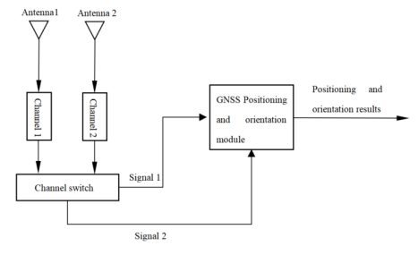
To achieve orientation, the key is to solve for the baseline vector. The measurement process mainly includes the following steps:
1. Signal reception: Each GNSS antenna receives signals from multiple GNSS satellites.
2. Differential correction: Differential techniques such as RTK correct the received observations and significantly improve measurement accuracy.
3. Baseline calculation: Differences between the signals received by the two antennas are used to calculate their relative position, forming the baseline vector.
4. Attitude solution: The platform's attitude angles are determined from the relationship between the baseline vector and a known Earth reference coordinate system.
How to Improve Orientation Accuracy
1. Use high-quality receivers and antennas: High-performance GNSS equipment reduces noise and provides more stable, accurate signal reception.
2. Optimize the antenna layout: The spacing and arrangement of the two antennas directly affect orientation accuracy and should be selected for the application and operating environment.
3. Use multiple frequencies and constellations: Combining L1, L2 and L5 observations with GPS, GLONASS, Galileo and BeiDou helps correct ionospheric delay, increases satellite availability and improves reliability.
4. Reduce multipath: Work in open areas, avoid nearby reflective objects such as buildings and trees, and use antennas and receivers designed to suppress multipath effects.
5. Integrate assisted orientation: Combining GNSS with other sensors, such as an Inertial Navigation System (INS), can improve robustness and accuracy.
Applications
1. GNSS compass: Provides real-time true-north information with high accuracy, without dependence on geomagnetic fields, and can operate near polar regions.
2. Rapid initial alignment for INS: Supplies true-north azimuth to an INS for fast, high-precision initial alignment and improved response.
3. Deformation monitoring: Continuous observation of a vector between two spatial points reveals relative three-dimensional movement. Applications include tectonic movement, water-level change, crustal and structural deformation, mining subsidence and offshore platform subsidence.
4. GNSS INS integrated heading: Combining satellite orientation with INS provides real-time heading for drones, unmanned reconnaissance vehicles, ships and aircraft.

